Darnley Bay Gravity & Magnetic Anomaly

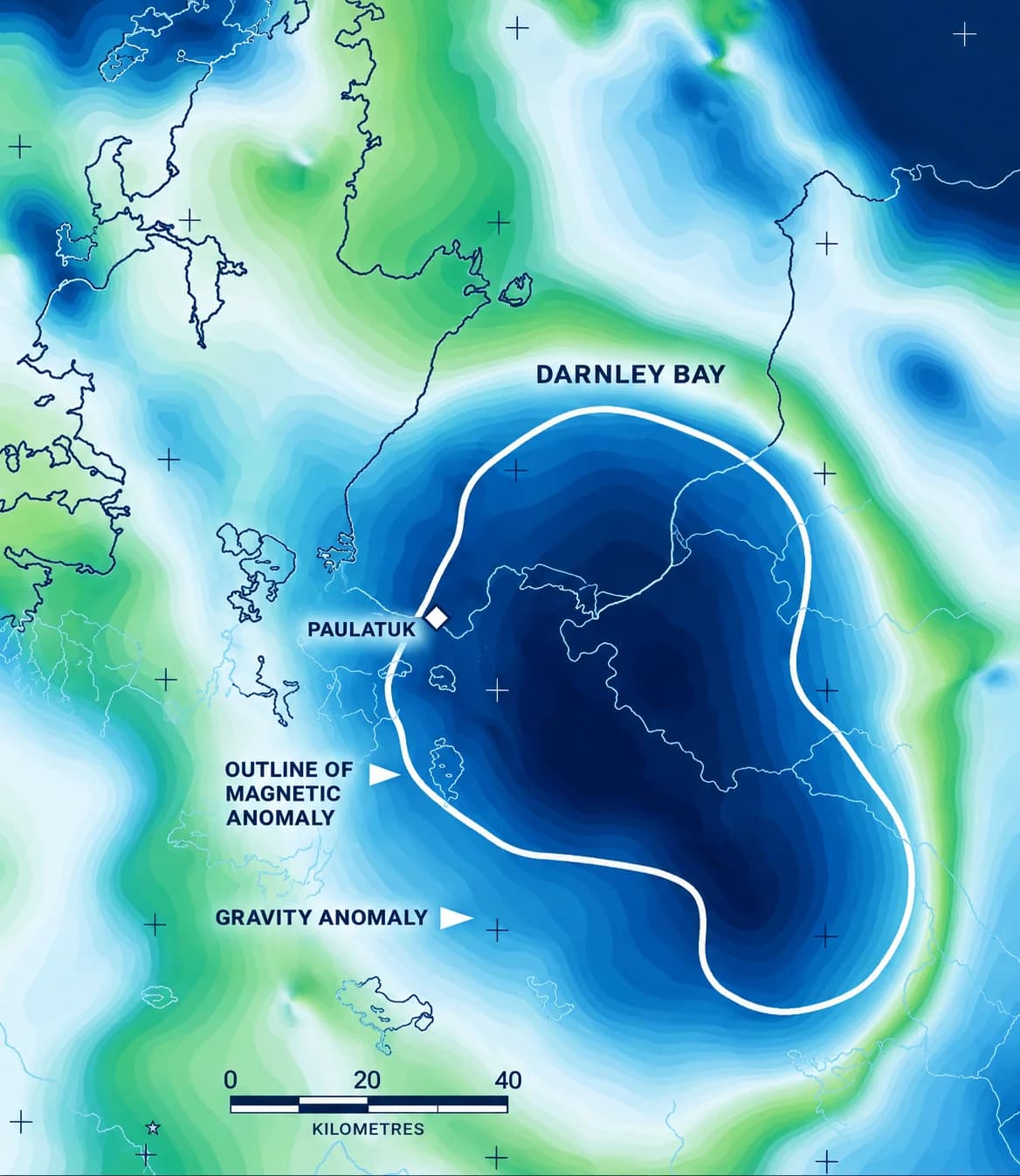
Gravity map of the Darnley Bay anomaly, showing the outline of the magnetic anomaly and the hamlet of Paulatuk
Source: Company Produced Image

Strong Land Based Discrete Gravity Anomaly at 132 Milligals (“mGal”)4 5

Darnley BaySudbury BasinNoril’skBushveld ComplexOlympic Dam
132
30
25
80
17
03570105140

Source: Generation Mining Corporate Presentation, March 2019

100 × 60km

Darnley Bay has a large gravity anomaly measuring 100 x 60 kms.

Gravity Anomaly

A specific area where the density of rocks at depth is greater than the surrounding rocks. This can indicate the presence of a mineral deposit because metal bearing rocks are denser.

Source: ⁴ Elton Resources NI 43-101 Technical Report, August 2024Note: ⁵ See Notes section of the presentation

Project Location

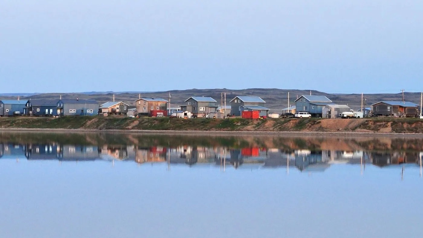
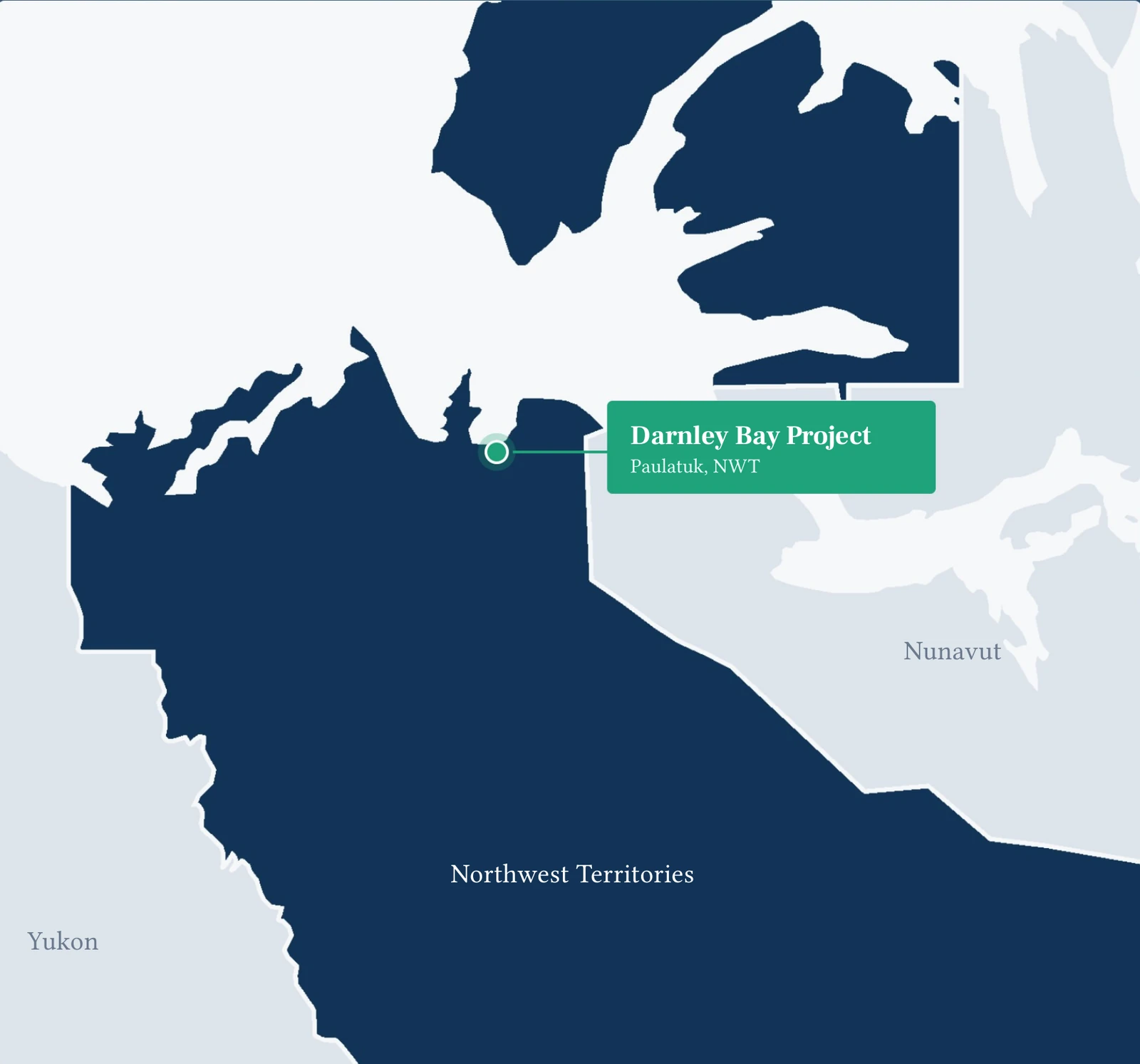
Situated in proximity to the hamlet of Paulatuk on the mainland, approximately 387 km east of Inuvik along the Arctic coast, the project is positioned within the Inuvialuit Settlement Region ("ISR"). The ISR, established in 1984 through the Inuvialuit Final Agreement by the Government of Canada, is dedicated to the Inuvialuit people.

Significant Location Highlights

  • Current population of Paulatuk is 375 people (2022).
  • Inuvialuit and NWT jurisdictions are mining-friendly.
  • Natural seaport served by commercial barge.
  • The Project area is directly accessible by commercial and charter air, barges and ocean carriers.
  • 1,220 m commercial airport can accommodate a wide range of aircrafts, including a Hercules transport plane.
  • Amenities include health centre, hotel, grocery, and restaurant.
Regional map showing the Darnley Bay Project at Paulatuk on the Arctic coast of the Northwest Territories, with Yukon and Nunavut adjoining

History

Everybody knew it was there. Nobody reached it.

Four holes have been drilled toward the anomaly. None reached the targeted formations.

1954 – 2023 · scroll or use the arrows

1954

A compass deviates

International Nickel Limited overflew the Paulatuk area and noted a significant deviation in the aircraft's compass.

1969

The anomaly is discovered

Discovered in 1969 by the Geological Survey of Canada during a regional survey. In 1973 the GSC carried out an aeromagnetic survey over the gravity anomaly, which defined a coincident positive magnetic component.

1993

Darnley Bay Resources is formed

Darnley Bay Resources Limited was formed in 1993 to explore the anomaly. Between 1993 and 2000 a significant amount of exploration was completed on the project, including aeromagnetic, gravity and electromagnetic surveys.

2000

The first hole falls short

DBR drilled a vertical drill hole which encountered considerable problems prior to reaching its targeted depth of 2,300 m. It was terminated at a depth of 1,812 m due to ground water pressure.

2010

Three more holes

Exploration continued with three drill holes. The drill holes did not reach the targeted formations due to glacial overburden, blocky ground, clay seams and deteriorating weather.

2015

The GSC returns

The GSC completed a magnetotelluric survey across the Brock Inlier and the Darnley Bay anomaly.

2018

The anomaly is better defined

A number of additional geophysical programs between 2013 and 2018 were completed by Pine Point Mining and Generation Mining, which better defined the anomaly. In July 2018 Generation completed an MT survey over a 40 by 50 km area on the anomaly.

2022

Elton acquires the project

In December, Elton Resources signed a binding agreement with Generation Mining Limited to acquire the Darnley Bay project for C$5 million, which included all historic data.

2023

The concession is signed

In January, Elton Resources signed a binding Concession Agreement with the Inuvialuit Regional Corporation to explore the Darnley Bay project.

2018 Magnetotelluric Survey

116 soundings that changed the question.

Completed by Quantec Geoscience Limited. Magnetotellurics measures how the ground conducts natural electromagnetic fields; massive sulphide is far more conductive than the sedimentary rock around it.
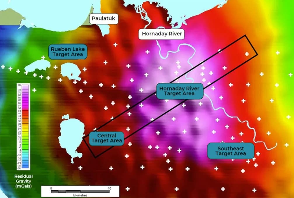
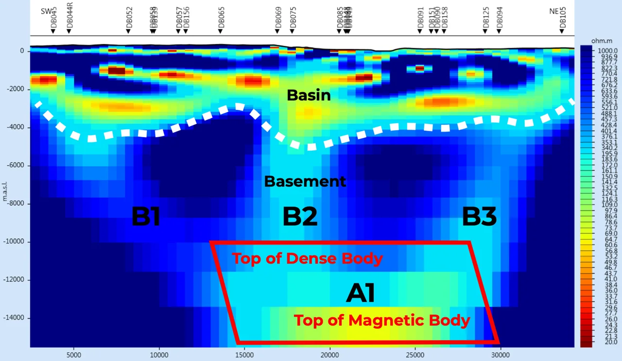
  • A total of 116 MT deep-searching geophysical soundings were collected on the Darnley Bay property, over a 40 by 50 km area, blanketing the Darnley Bay geophysical anomaly.
  • Analysis of the MT data has indicated four large Target Areas.
  • All four Target Areas contain MT anomalies that overlap with strong gravity and magnetic anomalies.
  • MT anomaly locations range from 800 to 1,200 metres in depth to the top of the source.
  • Each of the MT anomaly targets is larger than one square kilometre and is marked by a significant decrease in resistivity.
2018 MT survey site locations
2018 MT survey results

Exploration Drill Programme

Four holes. Five thousand metres.

The Company will commence its proposed 5,000 m exploration drill programme, consisting of up to four drill holes, with one hole planned in each of the four target areas highlighted by the 2018 MT survey.
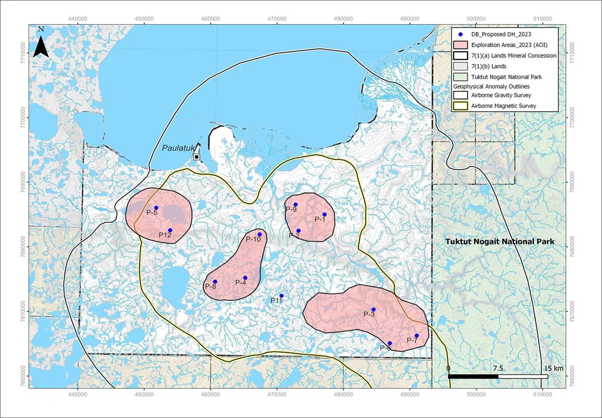
Proposed 2023 drill holes across the four exploration areas, with the mineral concession boundaries, airborne gravity and magnetic survey outlines, and Tuktut Nogait National Park

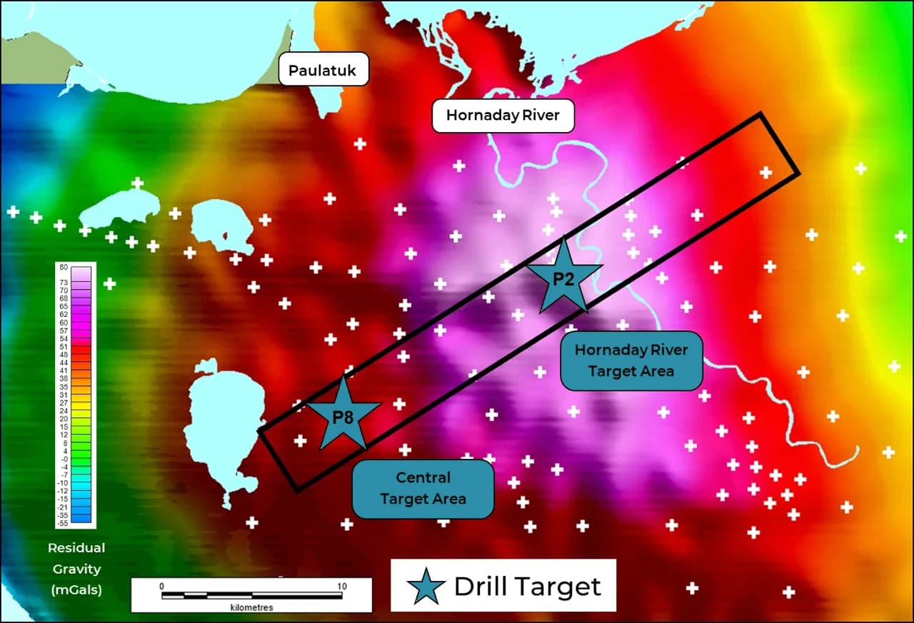
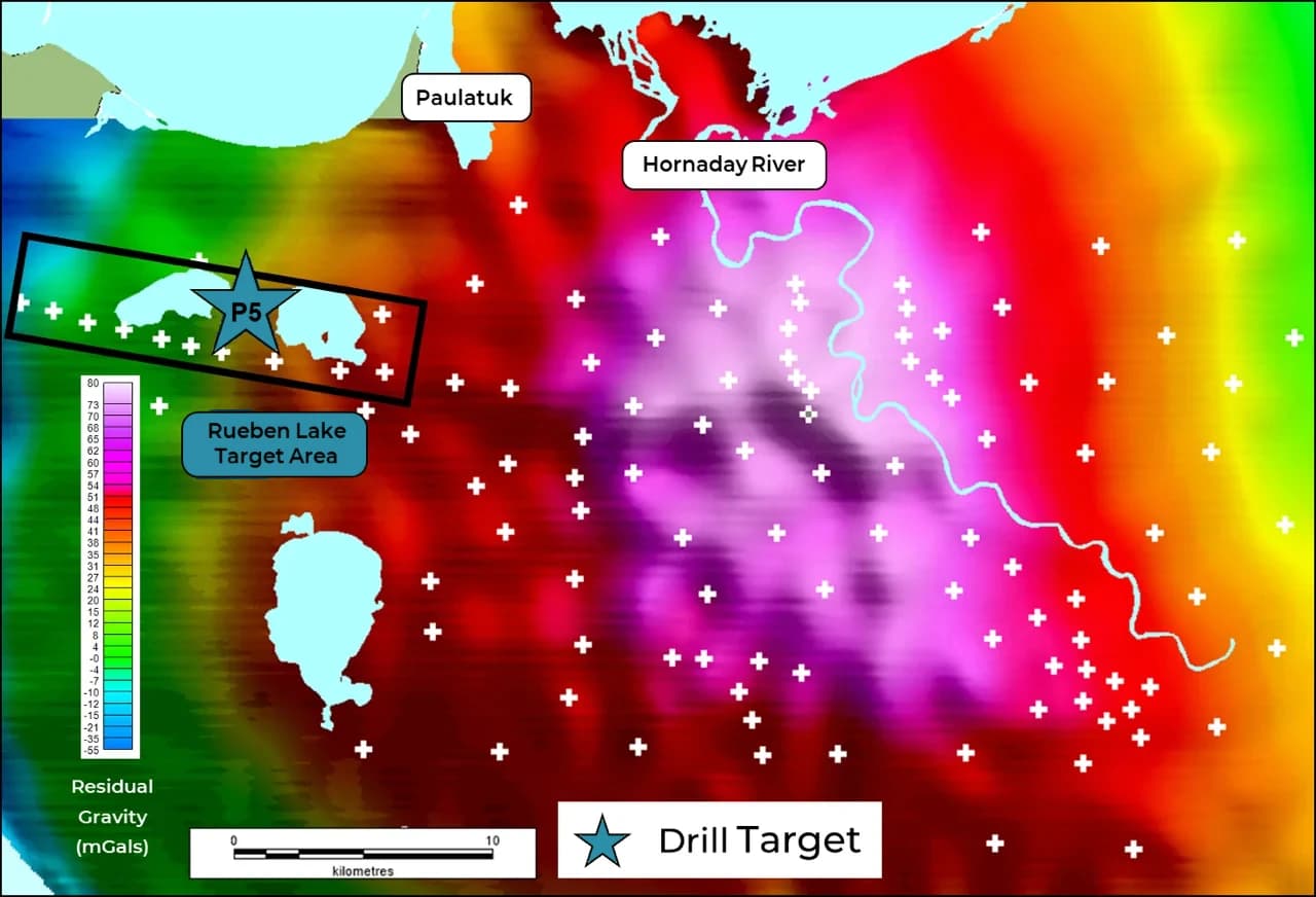
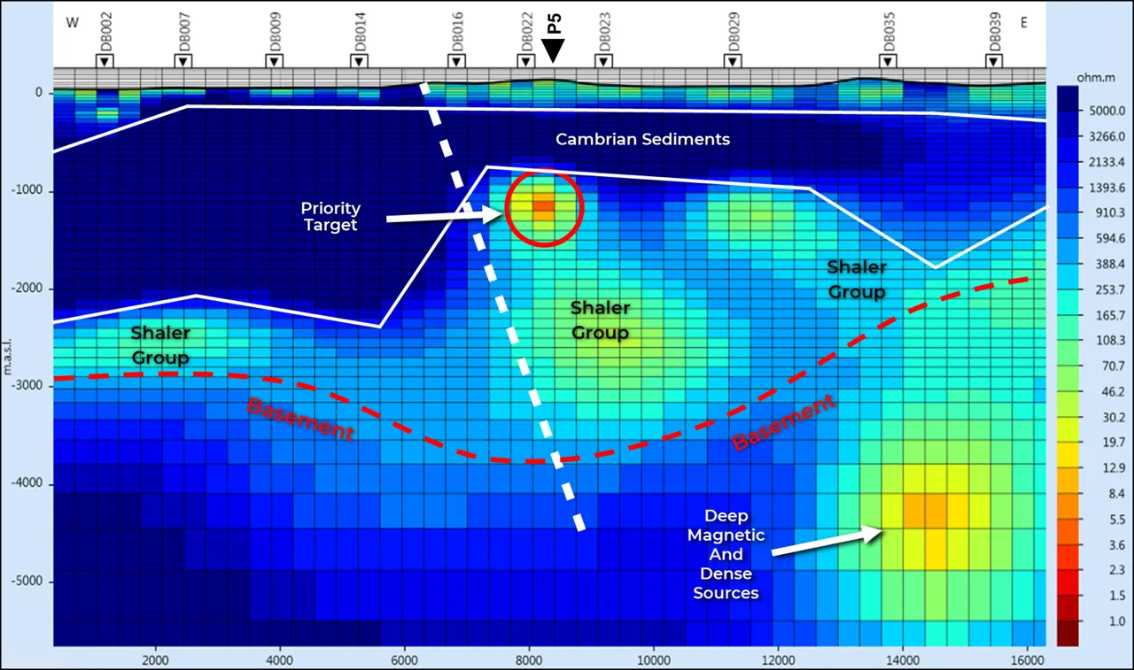
Priority targets. P-5 (Rueben Lake), P-8 (Central) and P-2 (Hornaday River) are the holes planned to test the priority target areas identified by the 2018 MT survey.
P5 Drill Target

Rueben Lake
  • Magnetic and gravity peaks coincide with an MT anomaly, which represents our Priority Target.
  • Drill hole P5 will test the Priority Target in the Rueben Lake area.
  • The MT image highlights the various basin layers and deep magnetic sources located under the basement.
P5 drill target location, over residual gravity
P5 drill target, MT cross section

P8 & P2 Drill Target

Central and Hornaday River
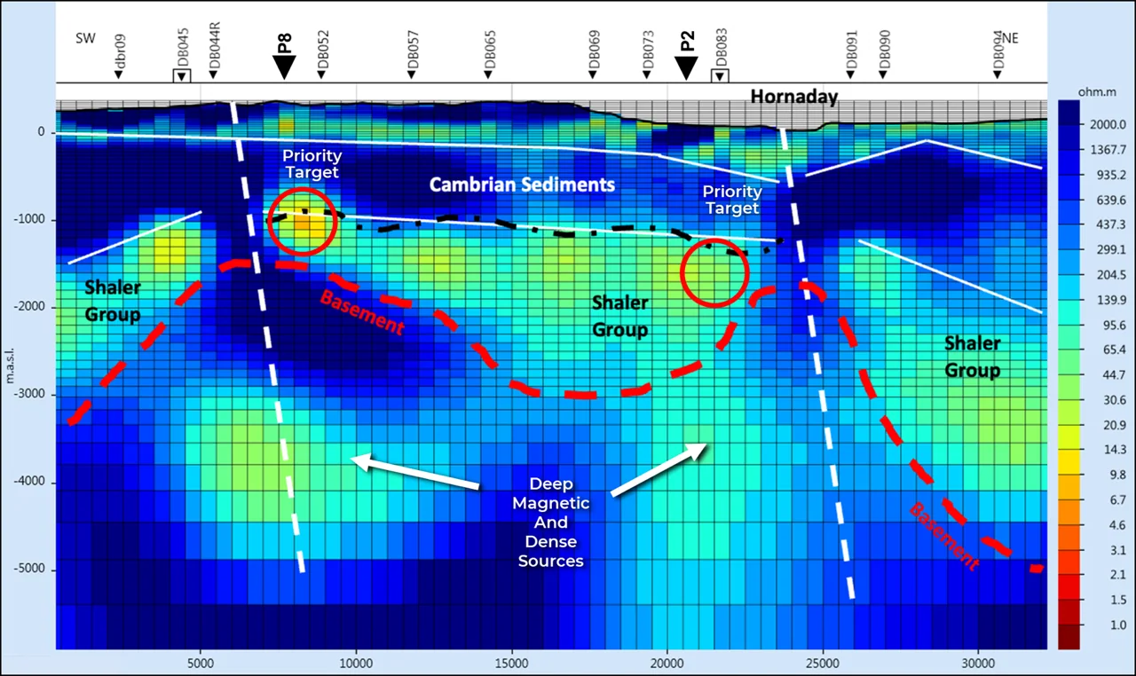
  • Magnetic and gravity peaks coincide with MT anomalies, which represent our Priority Targets.
  • Drill holes P8 and P2 will test both Priority Targets in the Central and Hornaday River areas.
  • The MT image highlights the various basin layers and deep magnetic sources located under the basement.
P8 and P2 drill target locations, over residual gravity
P8 and P2 drill targets, MT cross section

Figures reproduced from Elton Resources Corp. Magnetotelluric survey completed by Quantec Geoscience Limited, 2018.

The Darnley Bay Project is at an early exploration stage. There is no current mineral resource estimate for the project. Geophysical anomalies are not mineral deposits, and the presence of a gravity, magnetic or magnetotelluric anomaly does not establish the presence of mineralisation of any kind, in any quantity, or of any economic significance. The exploration programme described is planned and remains subject to financing, permitting, community agreements, weather and equipment availability. Noril'sk is referenced solely for deposit style and is not geographically proximate to Darnley Bay; investors should not rely on comparables. All scientific and technical information has been reviewed and approved by David White, P.Geo., a qualified person for the purposes of National Instrument 43-101.